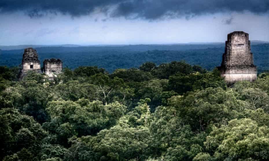
Visions of “lost cities” in the jungle have consumed western imaginations since Europeans first visited the tropics of Asia, Africa and the Americas. From the Lost City of Z to El Dorado, a thirst for finding ancient civilisations and their treasures in perilous tropical forest settings has driven innumerable ill-fated expeditions. This obsession has seeped into western societies’ popular ideas of tropical forest cities, with overgrown ruins acting as the backdrop for fear, discovery and life-threatening challenges in countless films, novels and video games.
Throughout these depictions runs the idea that all ancient cities and states in tropical forests were doomed to fail. That the most resilient occupants of tropical forests are small villages of poison dart-blowing hunter-gatherers. And that vicious vines and towering trees – or, in the case of The Jungle Book, a boisterous army of monkeys – will inevitably claw any significant human achievement back into the suffocating green whence it came. This idea has been boosted by books and films that focus on the collapse of particularly enigmatic societies such as the Classic Maya. The decaying stone walls, the empty grand structures and the deserted streets of these tropical urban leftovers act as a tragic warning that our own way of life is not as secure as we would like to assume.
For a long time, western scholars took a similar view of the potential of tropical forests to sustain ancient cities. On the one hand, intensive agriculture, seen as necessary to fuel the growth of cities and powerful social elites, has been considered impossible on the wet, acidic, nutrient-poor soils of tropical forests. On the other, where the rubble of cities cannot be denied, in the drier tropics of North and Central America, south Asia and south-east Asia, ecological catastrophe has been seen as inevitable. Deforestation to make way for massive buildings and growing populations, an expansion of agriculture across marginal soils, as well as natural disasters such as mudslides, flooding and drought, must have made tropical cities a big challenge at best, and a fool’s gambit at worst.
Get the Guardian’s award-winning long reads sent direct to you every Saturday morning
Overhauling these stereotypes has been difficult. For one thing, the kind of large, multiyear field explorations usually undertaken on the sites of ancient cities are especially hard in tropical forests. Dense vegetation, mosquito-borne disease, poisonous plants and animals and torrential rain have made it arduous to find and excavate past urban centres. Where organic materials, rather than stone, might have been used as a construction material, the task becomes even more taxing. As a result, research into past tropical urbanism has lagged behind similar research in Mesopotamia and Egypt and the sweeping river valleys of east Asia.
Yet many tropical forest societies found immensely successful methods of food production, in even the most challenging of circumstances, which could sustain impressively large populations and social structures. The past two decades of archaeological exploration, applying the latest science from the land and the air, have stripped away canopies to provide new, more favourable assessments.
Not only did societies such as the Classic Maya and the Khmer empire of Cambodia flourish, but pre-colonial tropical cities were actually some of the most extensive urban landscapes anywhere in the pre-industrial world – far outstripping ancient Rome, Constantinople/Istanbul and the ancient cities of China.
Ancient tropical cities could be remarkably resilient, sometimes surviving many centuries longer than colonial- and industrial-period urban networks in similar environments. Although they could face immense obstacles, and often had to reinvent themselves to beat changing climates and their own exploitation of the surrounding landscape, they also developed completely new forms of what a city could be, and perhaps should be.
Extensive, interspersed with nature and combining food production with social and political function, these ancient cities are now catching the eyes of 21st-century urban planners trying to come to grips with tropical forests as sites of some of the fastest-growing human populations around the world today.
As with “agriculture”, people in the west tend to view the concept of a “city” through a narrow lens. They are compact, densely populated areas, the home of administrative and political elites, full of bustling trade and manufacturing, and fed by vast agricultural fields and animal herds that are often located at some distance from the city boundaries.
This view seems somewhat out of place in tropical forests, where sweeping fields of uniform crops, grazing animals and dense settlements can lead to drastic deforestation, soil erosion and eventually starvation and social disintegration. As a result, where such seemingly “compact” cities have been identified in the tropics – for example the Classic Maya of south-eastern Mexico, Guatemala, Belize, and western Honduras and El Salvador – scientists have tended to assume that these societies were too much for their tropical forest landscapes, leading to degradation, popular rebellion and ultimately abandonment.
Maya urban forms began to appear about 800BC. Cities, monumental stone architecture and writing all gradually emerged at certain key political centres, led by kings and fed by the North and Central American staple crops of maize, beans and squash. It was during the Classic period that things truly took off, especially in a region that has become known as the southern lowlands (including northern Guatemala, Belize and south-eastern Mexico). Between AD250 and 900, growing populations, more cities, more monuments and more inscriptions appeared. Major cities such as Tikal and Calakmul had populations of as many as 120,000 people.
Although many of these cities were located on soils particularly suited to productive maize agriculture, there was one problem. Rainfall was not consistent throughout the year, and the geology often made the capture and storage of precious water through the dry months challenging. Many scholars have argued that major droughts brought the system to its knees in the Terminal Classic period, between AD800 and 900 in the southern lowlands. In this view, the large centres and their political classes had over-reached, cutting down trees to build their monuments and planting their corn on poor soils. With their populations precariously sustained across a heavily altered landscape, there was nothing they could do when drought came. People lost faith in elites, construction stopped, famine ensued and the Classic population dispersed itself across the landscape.
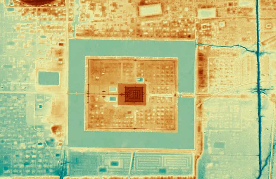
So often goes the story of the Classic Maya. Amazingly, however, far from being compact, we now know that even in the most well-known of Maya centres, like Copan and Tikal, the population was relatively dispersed. Instead of having fields outside and politics inside, fields were located throughout the urban infrastructure and residences. And instead of a small focal point, cities spread over 100 sq km. Recent studies of Tikal have shown a network of moats, dwellings, reservoirs and pyramid clusters that extend out from a single hill for up to 200 sq km into the surrounding landscape.
Innovative aerial surveys have now made similar findings across the Maya world. In almost all instances, instead of isolated urban buds, scientists have found vast landscapes of small and large centres connected by dispersed agrarian landscapes, residential areas, causeways and a complex, interlinking system of dams, reservoirs, sinkholes, channels and swamps that supported growing populations through even the driest of seasons. As leading Mayanist Prof Lisa Lucero, of the University of Illinois, puts it, “the Classic Maya knew the importance of water and of fertile agricultural soils, the latter dispersed in variously sized pockets, mirrored by a dispersed agricultural settlement. This low-density approach to cities was a logical, innovative solution.”
The Classic Maya also had far more diverse and sophisticated economies than has often been appreciated. Alongside the key crops, archaeobotanists have shown that the planting of avocados, pineapples, sunflowers, tomatoes and manioc added to a dispersed settlement and lifestyle. The Classic Maya are also known to have penned, fed and fattened wild turkeys and deer for their key protein sources.
Scientists have found evidence that diverse “forest gardens” sustained these cities. Based on ethnographic study of, and testaments from, Maya communities today, this type of cultivation, called milpa (or kol in the local Yukatek language), involves the use of multiple crops, and the movement of fields, allowing different parts of the forest to grow back and patches of soil to rest and restock before planting begins in a locality again. We also know that instead of indiscriminately planting in soils of all types, the Classic Maya actually followed rich veins of particularly productive soils, giving their field systems a winding appearance that snaked along rivers and up slopes. They even added special plants, like water lilies, to reservoirs. These plants are incredibly sensitive to water quality, only growing under clean conditions, and allowed people to monitor the buildup of stagnant water and thus guard against disease.

The difficulty of maintaining large populations in a highly seasonal tropical landscape, where water was often in demand, did eventually take its toll in many parts of the Maya “heartlands”. Detailed research by climate scientists has shown that from roughly AD800 onwards there were more and more droughts. Some studies also suggest that deforestation, which varied at each of the hundreds of Maya centres, may have exacerbated the water shortage. In the southern lowlands, where surface water was hard to find at the best of times, many cities, including Tikal, saw failing agricultural returns, growing hunger and stress. As resources grew scarce, inter-city violence became more frequent. Since kings claimed close ties to the gods, in the face of droughts and failed crops, their source of political power was called into question. People refused to work on pyramids and palaces, seeing that they made no difference to their fortunes. Ceremonial centres were abandoned in the southern Maya lowlands, the ruins left for scientists arriving centuries later.
This may certainly seem like a rapid, uncompromising disaster. But the truth is more complicated. Given such long-term knowledge of their ecosystems, their well-tuned economies and sophisticated water management – things that 21st-century urban systems may often lack – is a sweeping, rapid collapse truly likely?
In fact, Maya centres such as Chichen Itza actually flourished into the Postclassic period (AD900-1520), some right up until the Spanish arrival, finding new sources of freshwater such as sinkholes, lakes and rivers. In many areas, it seems that the independent farmers – who were key links in the long chain of Classic Maya urban systems – carried on, albeit with much smaller populations. In the region of El Pilar, surrounding the ceremonial centre of Tikal, forest gardens were managed by farming communities through the rise and fall of Tikal.
This diverse agriculture persists among Indigenous Maya communities, who still occupy many parts of the region today. These groups still practise traditional manufacturing and landscape management. Urban archaeologists, like our societies in general, tend to focus on the photogenic remains of elite structures that attract tourists and film crews. When your tropical city is built on sprawling networks of independent farmers and craftspeople, it is easy to miss the remarkable resilience inherent in the foundations of the system.
Perhaps the most famous set of ruins emerging out of a jungle is located in the Greater Angkor region of Cambodia. Every year, tourists flock to the temple of Angkor Wat, which became the religious centre of the Khmer empire in the 12th century AD. Few of them, however, realise that this monumental shrine is just a tiny element of what was once a sprawling society.
Urban settlements began to emerge in this part of the world in the first millennium BC. By the ninth century AD, the new capital of the Khmer empire – the dominant state of mainland south-east Asia at the time – had formed in the Angkor region. The capital, Yasodharapura, was characterised by massive water reservoirs and a series of walled administrative palaces and Buddhist and Hindu temples, which thrived for over half a millennium, until the 14th century. For a long time, archaeologists focused their attention on the impressive, compact “ceremonial” centres like Angkor Thom and Angkor Wat.
But then two things happened. First, starting in the 1990s, the French archaeologist Christophe Pottier and his local collaborators undertook decades of on-the-ground survey work, identifying vast numbers of construction features, large and small, across an entire Greater Angkor region.

And then came a revolutionary new research method: light detection and ranging (Lidar). “Lidar allows us to virtually strip away vegetation,” says Damian Evans, one of the leading experts applying this method to tropical archaeology. “Using a laser scanner attached to an aircraft, we carpet the terrain below us with pulses of lasers, collecting billions of points. Some bounce back from the trees, but others slip through, allowing us to build a model of what lies beneath.”
What they have found at Angkor is simply mind-boggling: an urban residential area of more than 1,000 sq km has emerged alongside a modified landscape of 3,000 sq km. This makes Greater Angkor the most extensive pre-industrial settlement complex anywhere on Earth, and larger even than cities such as Paris today. It also revolutionises our understanding of how this ancient megacity operated.
As in the case of the Classic Maya – where Lidar has also exposed vast, settled urban landscapes – rather than being solely composed of compact ceremonial centres, Angkor was another example of low-density urban sprawl. At ceremonial centres like Angkor Thom, Lidar filled in the apparently spacious courtyards to reveal that they were once inhabited by people living in wooden pile houses within the stone walls. Numerous sprawling domestic mounds, smaller shrines and rice fields extend from right up against the boundaries of sites such as Angkor Wat, out across the lowlands and into the hills.
Angkor’s urban populace used the tropical forests as well as the open fields, exploiting wild palms, vegetables and fruits in managed orchards, and ensuring that some forest cover persisted. Rivers and ponds provided fish, while pigs, cattle and chickens roamed the busy streets. Studies have shown a vast, branching network of water transport, and storage was built to support the expanding human and animal population. Unsurprisingly, this vast urban metropolis did place a strain on the tropical landscape. There is clear evidence of serious deforestation and soil erosion, though the impact was dispersed rather than focused on any single area.
Angkor’s time did eventually come to an end. During the late 14th century AD, increasingly extreme climatic swings between drought and deluge ruptured parts of the water network and took their toll on farming yields. Urban areas, with their palaces and temples, were eventually abandoned as independent farmers saw no reason to stay under the political umbrella of elites.
But, again, instead of complete collapse, what happened next was more interesting. The rulers moved to new, more compact cities in the Phnom Penh area, where the current capital of Cambodia still stands to this day. Meanwhile, the farmers moved to numerous small towns along the banks of the Mekong River and Tonle Sap Lake, which offered stable watercourses.
As with the Classic Maya, then, the governing system certainly failed, particularly in the wake of climatic challenges facing a region prone to seasonal variation in rainfall. The eventual abandonment and upheaval seen at Greater Angkor should not be underplayed. The elite thought up a new strategy and moved to new sites of power, while the farmers remained in the landscape that had provided for them for so long, albeit focusing their efforts on more profitable areas for cultivation and herding.
Once we cast our eyes away from the overgrown walls of temples, we can begin to see how Greater Angkor represented a vast, highly resilient approach to urban living in the tropics.
Compared to the seasonally dry tropical forests of Cambodia, the rainforests of the Amazon Basin are another challenge altogether for urban societies. In fact, the heat, the humidity and the acidic, often flooded, soils led some archaeologists and anthropologists to assume that both cities and settled agriculture were environmentally impossible here. Most surviving Indigenous communities in these forests were, after all, living in small villages with no clear evidence of social hierarchy. Indeed, today, expanding infrastructure, development, plantation agriculture and ranching can do untold harm to these environments.
But growing numbers of studies by dedicated teams of archaeologists, anthropologists, environmental scientists and Indigenous communities have revealed substantial garden city landscapes of earthworks, clustered structures, and road-like paths across the Amazon.
In and around the Xingu River, these settlements reached their peak between AD1250 and 1650, just prior to European arrival. Intriguingly, they show a similar pattern to the cases of “agrarian-based, low-density urbanism” practised by the Classic Maya and in the Greater Angkor region. In each case, large towns at central points were surrounded by monumental wooden walls and ditches, connected to a number of satellite villages by pathways cleared through the forest. Instead of mass deforestation, these settlements were separated by intact forest, which was used for the management of fruit-bearing trees, farming freshwater turtles and fish in ponds, and more open fields for manioc and maize.

Many years of research have also documented a similar series of urban-like settlements at Marajo Island, right at the mouth of the Amazon River. Increasing in size and density until the start of the 14th century AD, population estimates for this region at its peak have been as large as 100,000. Whatever the true size, as in the garden cities of the Xingu, analysis of human remains have shown that the occupants of Marajo Island, as well as the nearby Maraca region, fed themselves through a mixed system of foraging for diverse plants, hunting of wild animals and fishing or penning freshwater resources in and around intact rainforest, with some limited cultivation of manioc and maize in more open patches perhaps occurring in addition.
Ultimately, these Amazonian forms of agrarian-based, low-density urbanism may have enabled populations as large as 20 million to have existed across Amazonia by the time of European arrival. Given that the population of all of Europe in 1492 is estimated to have been between 70 and 88 million, this represents a considerable number of human lives being sustained within what must undoubtedly be seen as substantial urban types of settlement, albeit very different from our usual ideas of cities.
Not all ancient cities in the tropics looked like the ones described above. Compared with more compact city forms, they were certainly rarer and more prone to disappear from a region. However, these examples provide an important way of looking at past cities in tropical forests, and can help us to see that they were obviously possible and incredibly inventive. The diverse use of wild plants and animals in managed forest patches, fishing in rich freshwater settings and the mobile use of open areas for crops created conditions sufficient for some of the largest cities in the pre-industrial world.
Dispersing the impacts of growing populations across satellite settlements tempered the loss of unique tropical biodiversity and soil quality in the face of growing human pressures. There were certainly enormous challenges, particularly in seasonally dry forests, where human-induced deforestation and climate breakdown could tip the scale from precarious viability to failure. But the hardiness of these cities can be seen in their often long spans of existence – longer than 500 years in the case of Greater Angkor and some Classic Maya urban centres.
The strength of agrarian-based, low-density urbanism remains an attractive model for present-day urban planners across the tropics looking for green cities that balance urgent conservation and environmental needs, political and cultural infrastructure, and growing urban populations.
There are many, many more examples of cities built by pre-colonial states and empires across the tropics. A significant number of these, such as those of the Amazon and the Postclassic Maya, were still flourishing at the time of European contact. They were often even actively admired by European visitors. So why do we tend to think of tropical forests as hostile to large, food-producing human populations? Why do all our popular assumptions fit ruins and small, isolated Indigenous bands of foragers to these environments, rather than lively, humming streets, residential blocks and monumental constructions that could stand the test of time? It is time for a rethink.
Adapted from Jungle: How Tropical Forests Shaped the World – and Us, by Patrick Roberts, published by Viking on 1 July and available at guardianbookshop.com