In 1867 the river at Windsor, north-west of Sydney, rose 19 metres, causing the biggest flood known to Europeans in Australia.
“The town of Windsor itself is almost entirely submerged and the country for miles around is underwater,” the Sydney Morning Herald reported.
“The plain on which Windsor is partly situated unites with South Creek and Eastern Creek to form a vast inland sea over the surface of which when the wind has been high the broken crested billows roll with as much force and volume as they do during a moderately squally day on Sydney Harbour.”
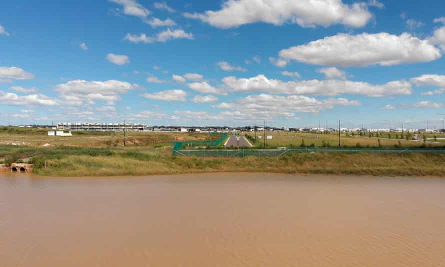
Neighbouring areas such as Riverstone, Vineyard, Marsden Park North and Penrith Lakes have also flooded regularly since, and were again submerged after the downpours of the past week.
Yet this is where the New South Wales government hopes to expand Sydney. Some housing developments have already been approved and are under way, despite some having flood risks of 1% – meaning they would flood in a one-in-100-year flood.
Successive governments have agreed to open up flood-prone land in Sydney, amid pressure from landowners, developers and councils and the challenge of housing Sydney’s growing population.
The pressure often comes from landowners, and their causes are championed by local MPs and councillors. Despite the ban on developer donations at state level, the largesse from developers is still flowing to the federal campaign accounts of both parties.
A history of pushing the envelope
Debate over development on the Hawkesbury-Nepean flood plain – and who is to blame when floods inevitably inundate houses – has raged since settlement.
The primary responsibility is now with councils, which issue certificates that inform property owners of the flood risk and zonings.
But increasingly the state government has taken control of major planning decisions for Sydney.
Until 1984, state government planning policies were aimed at preventing development in flood-prone areas, with a hard and fast rule about applying the one-in-100 flood levels.
But amid fears that large parts of the Sydney basin would be effectively off limits for development, there was a change in policy under the then Liberal government.
In 1986 it released a manual to assist local councils in the management and development of flood-prone land.
It was updated in 2001 and again in 2005 under Labor. Each time it gave councils more flexibility, often couched in language that appeared to be concerned with flood risk.
The policy told councils to look at flood risk in a strategic way, rather than on an individual proposal basis, and to look at ways to manage floods in conjunction with the state government.
The 2005 manual, which is still current, puts it this way: “The policy promotes the use of a merit approach which balances social, economic, environmental and flood risk parameters to determine whether particular development or use of the floodplain is appropriate and sustainable.
“In this way the policy avoids the unnecessary sterilisation of flood prone land. Equally it ensures that flood prone land is not the subject of uncontrolled development inconsistent with its exposure to flooding.”
In 2020, in the light of the Brisbane floods of 2011, NSW announced plans to toughen up its planning approach on flood plains. It wanted councils to consider scenarios beyond the one-in-100 floods.
The documents went on exhibition at the height of the Covid-19 lockdown. There was significant pushback from developers, and the new package is still “under consideration”.
Meanwhile the government is considering raising the wall on Warragamba Dam, which might mitigate some floods, but not all.
Scientists such as the Australian National University’s Prof Jamie Pittock have warned that raising the dam wall will not be effective in stopping flooding in the Sydney basin because only about half of the flow into the Sydney basin is moderated by the dam.
Thinking a higher wall will eliminate flood risks could “lull governments, businesses and people into thinking they are safe so they are not prepared for the inevitable big one”, Pittock says.
Raising the wall would almost certainly add to the pressure to approve development in areas prone to flooding such as the North West growth corridor and Penrith Lakes.
Flood-prone areas get development go-ahead
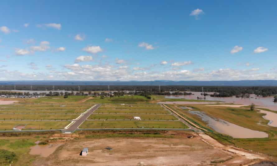
Clydesdale, a historic property in Marsden Park North, is one example of how the pressure to develop has driven decisions. Marsden Park has been slow to be developed because of the flood risk.
Almost all of Clydesdale is classified as flood-prone and more than half is within the one-in-100-year flood zone.
But lately there has been a change of heart and several housing estates, including Clydesdale, have been given the go-ahead.
Clydesdale Property Development Group bought the property in August 2014 for $45m. Then in mid-2016, the then premier Mike Baird announced that the Warragamba dam wall would be raised.
Six months later, Clydesdale sold the property for $138.8 million. Development was given the go-ahead and lots are now on the market.
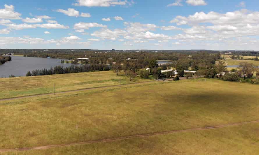
Another highly contentious flood-prone area is Penrith Lakes.
The 2,000-hectare site, a former quarry, is owned by Penrith Lakes Development Corporation (PLDC) – a consortium between building materials suppliers Boral, Holcim and Hanson that previously operated the quarry.
Part of the site was redeveloped during the Olympics as a whitewater facility, but there are more ambitious plans for waterways, parkland, recreation and some residential and employment zones.
Just how much is a matter of constant lobbying by developers.
In 2018 the government agreed to dual occupancy development on the larger residential sites after pressure from developers. “We heard from landowners at Penrith Lakes that dual occupancy is important, so we reassessed flood evacuation requirements for the area,” the planning department said.
In 2020 the government extended the employment zone by a further 40 hectares after another review.
Opponents of raising the dam wall fear that the local member for Penrith, Stuart Ayres, who is also the minister western Sydney overseeing the Warragamba project , wants to see much more residential development at Penrith Lakes.
Almost 2m tonnes of fill from the Westconnex tunnel project, also within Ayres’ portfolio, has been deposited at Penrith Lakes. This could raise levels to allow more residential development, but flood waters will still go somewhere – potentially into areas already developed.
Ayres rejects the idea that he wants to see more development at Penrith Lakes.
“I would not support large-scale residential urban development and anyone who suggests otherwise is perpetuating a politically motivated lie,” he told the Penrith Press last year.
Chas Keys, the former deputy director general of the SES in NSW, opposes the raising of the dam wall and is a strong advocate for a different approach.
“In NSW we continue to develop large amounts of flood-liable land for urban purposes, a result perhaps of governments and councils and development interests prioritising economic growth over community safety,” he told the NSW parliamentary committee investigating the raising of the dam wall.
Keys tells the Guardian: “One councillor who serves on a council in western Sydney refers to the 1867 flood as ‘the alleged flood’ even though we have incontrovertible historical records.”
He says the money would be much better spent on building more flood-proof evacuation routes from existing flood-prone suburbs.
The only exit route from Windsor capable of handling a 14-metre flood is now reaching capacity. There is no exit route at all if a 19-metre flood occurs again.
“We will just be left forever chasing our tail,” Keys says.
“We encourage further inappropriate development in flood-liable areas, magnifying the problem we have inherited from the past, and follow our error up with incomplete, partial efforts to mitigate the threat we have created.”