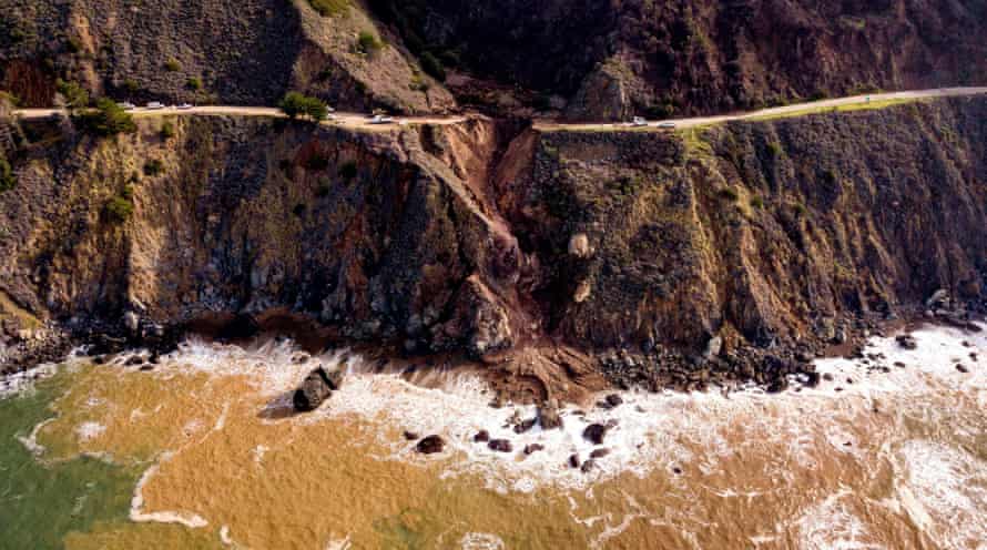
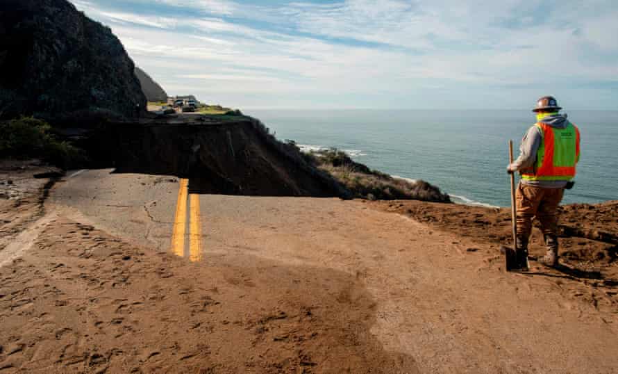
California’s Highway 1 has been ruptured by a landslide that is expected to keep 23 miles of the iconic road snaking through the state’s rugged coastal cliffs closed for months.
A severe winter rain storm last week caused a 150ft fissure along the picturesque thoroughfare tucked against Big Sur, with concrete, trees and mud falling into the sea below.
It’s not the first time. Landslides have been a longstanding feature of Highway 1. And with climate change and a deluge in tourism and traffic overwhelming both infrastructure and environmental ecosystems in the coastal region, the problems are only expected to get worse.
Highway 1 was deemed California’s first official scenic highway when it opened in 1937. The road stretches across more than 656 miles through the state, but is most known for the sections along California’s central coast, where millions of tourists each year admire the pristine and wild terrain where the mountains meet the Pacific.
It’s rumored the highway has never been fully operational from north to south for more than a year since its inauguration, with the elements that give it its world renown also spelling its doom.
With its steep slopes and diverse geology, the area has always been a site of cliffside churn, said Gary Griggs, a coastal erosion expert at University of California Santa Cruz. “This is not new, and it is not a surprise,” he added.
Caught between rising tides and crumbling cliff sides, maintaining the highway has become somewhat of a sisyphean task. Millions have been poured into the projects, with evidence of past engineering successes and failures etched into the concrete. There are bumps of new asphalt alongside snaking cracks, signs of repair and disrepair, as the process is repeated again and again.
“It all costs money,” Griggs said. “And, well, it is a tough road to repair.”
Griggs was called in to consult in 2017, when the Mud Creek slide covered a quarter-mile of the highway and ceded 15 acres of land to the sea. That rebuild took more than a year to complete, and cost roughly $54m.

Last week’s slide was roughly 165 miles south of San Francisco, and was probably caused by the disastrous environmental combination of a record-breaking fire season followed by big winter storms.
The slide took place just south of where the Dolan fire tore through roughly 125,000 acres last year. The burn scar from the months-long fire, with its blackened sand and sparse vegetation, made for slippery terrain, especially on the steep cliff sides along the coast. Then came the rain.
A so-called atmospheric river, a flowing column of condensed water vapor that spills severe amounts of rain or snow when it makes landfall, flooded the region, dropping 16 inches of rainfall – nearly double the amount the area has seen for the entire month on average. The soil was unable to absorb that amount of cascading water, causing mud and debris to flow, ultimately blocking and then overwhelming a drainage pipe under the highway.
“Landslides have been a historic feature of Highway 1 along the Big Sur coast,” said Kevin Drabinski, a spokesperson for California’s department of transportation (Caltrans). “But this storm was very large scale and left significant damage in its path.”
While the chasm that tore apart the road was the most dramatic scene of devastation, Drabinski added that 60 other locations along the highway were also damaged or blocked by debris.
Severe weather combinations like the one that occurred last week are no longer an anomaly. They fall in line with climate crisis trends and models marked by hot dry summers, bigger fires and long periods of drought peppered by intense rainstorms that cause floods and landslides.
“There is no question that climate change is occurring,” said Griggs, the coastal scientist. “It would not be surprising to see this happening more frequently.”
It’s not just fires, rain and landslides that threaten Highway 1 – parts are also being ravaged by the sea. Farther north at Gleason beach in Sonoma county, Caltrans has given up on preserving the route and has instead opted to build new sections farther inland. Smashed seawalls – remnants of attempts to buy more time against the encroaching waves – already line the shore. The state sank millions into emergency restorations as the coastline continued to erode by roughly 14 inches on average each year.

The $73m project could be an indication of what’s to come. By some worst-case scientific projections, sea levels could rise more than 9ft in California by the end of this century.
“It has always been a fragile environment fraught with concern and problems,” said Lesley Ewing, a senior coastal engineer with the California Coastal Commission, of Highway 1. “The roadway is crumbling because the ocean is just eating away at the cliffs.”
She sees opportunities where researchers and officials can be proactive in anticipating problems rather than waiting to react to them, including pushing parts of the highway farther from the eroding shore. However, that’s not an option everywhere.
Meanwhile, residents living along the famed road in the Big Sur area have been forced to adapt. “We have been through this many times before,” said Kate Novoa, a former lawyer who has lived on Big Sur’s largely undeveloped south coast and now runs a blog called Big Sur Kate.
“I have backups to my backups,” she said. “The way most of us live down here, is we are prepared to be isolated for an entire winter.” Novoa has cupboards full of dried and canned food. She runs her home on solar, and has not one, but two backup generators. There’s extra propane and lots of firewood.
“I have become more adept at what I need to do,” she said. That doesn’t mean it’s easy. Still, she thinks it’s worth it.
Even as conditions worsen and new dangers arise, Novoa said there was a reason why she and others in her community have chosen to adapt rather than move. “Most of us who live up here would never trade it for town,” she said. “It is one of the most beautiful places on the planet. It is very isolated and it is not for everybody – but I am never going to leave.”